Start with the route, not the map
Suriname is a left-driving country with a coastal road network, river crossings and a much less predictable interior. A compact Paramaribo itinerary can be a city-parking exercise. A run toward Albina or Nieuw Nickerie is a corridor plan with bridges, fuel and roadwork dependencies. A trip toward Brokopondo or farther south needs a vehicle and support decision before a sightseeing list is written.
The useful question is not whether a map can draw a line. It is whether the line still works after rain, a bridge restriction, a ferry delay, a missing fuel stop or a rental contract that excludes the route. Keep the first and last long stage in daylight, save a turn-back point and make the rental company confirm the exact road surface and permitted districts.

Licence, IDP and the rental counter
The national and commercial questions are different. The Rijwet 1971 sets the minimum age for a motor-vehicle licence at 18, while the Rijbesluit 1957 defines the vehicle categories. A visitor should carry the original home-country licence and passport, then confirm whether a local driving permission is needed for the length of the stay.
The police guidance about an international driving permit is aimed at holders of Surinamese licences travelling abroad, so it does not by itself answer every visitor’s rental question. The current Enterprise Paramaribo rental terms give a practical operator boundary: a valid licence from the country of residence is required; an IDP is recommended for non-English or non-Latin characters; and a non-Latin licence needs an IDP or notarised English translation. The Finalrentals terms are stricter and state that an international driver’s licence is mandatory.
Use the stricter preparation when the operator has not confirmed your documents. Send a scan of the licence and ask for a written reply that names the driver, vehicle class, age, licence tenure, IDP convention, translation, deposit, payment card, insurance excess and permitted roads. At pickup, photograph the registration, insurance evidence, plate, odometer, fuel, tyres, glass and every existing mark.
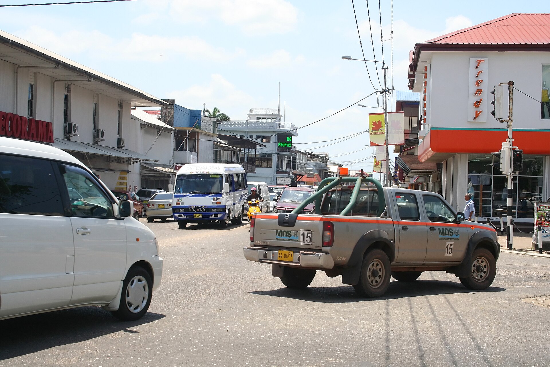
Left-side traffic, speed signs and city movement
Suriname’s traffic side is clear; the speed picture is more local. The Public Works cross-section guideline uses different design speeds for road categories and describes one-way destination roads, but a planning document is not a universal legal limit for every street. Read the signed limit and reduce speed for rain, poor drainage, pedestrians, animals, potholes, bridge repairs and traffic officers.
Paramaribo needs a block-by-block plan. Save the hotel entrance or car park before the final turn, and approach central streets with enough time to wait rather than stopping in a lane. One-way arrows, temporary cones and police directions can change the route around works or events. A missed turn is a reason to continue to the next legal turning point, not to reverse into a one-way street.
The Police Force traffic notices and the government’s public-works infrastructure dashboard are useful starting points for current contacts and infrastructure context. They do not replace the sign or officer at the road. Keep the rental plate and roadside number accessible when parking or passing a checkpoint.

East-West Link, bridges and ferry timing
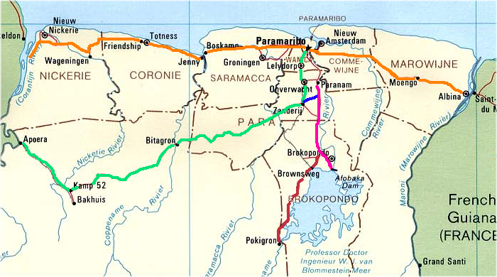
The northern East-West Link is the practical spine between the western Nickerie area and Albina through the Paramaribo region. Government infrastructure planning describes widening and future cross-border connections, while current road maintenance notices show why a corridor cannot be treated as a fixed motorway. Check the exact segment, daylight, fuel and weather before promising an arrival time.
The Jules Wijdenbosch Bridge carries the East-West Link across the Suriname River. The Coppename Bridge and other crossings create similar dependencies on the western side. Use the Public Works dashboard and current government notices to identify bridge and drainage work. Leave a buffer before a flight, lodge check-in or ferry departure, and never stop on a bridge to take a photograph.
At South Drain, the Canawaima Management Company notice describes the service between Suriname and Moleson Creek and acknowledges operational challenges. A previous government ferry notice shows that service can be suspended and resumed by announcement. Verify the sailing and border requirements on the travel date, then keep a full-day fallback.
The Albina crossing is different again. The official French Guiana border-post notice lists opening hours for the French post and directs travellers to Surinamese consular contacts for the Suriname side. It is a river crossing with separate immigration, insurance and vehicle rules. A rental car that reaches Albina is not automatically allowed onto a boat or into French Guiana.
Avobakaweg and the interior
Avobakaweg is the current name used by recent Roads Authority notices, while Afobakaweg remains common in older sources and route searches. The March 2026 repair notice describes subsidence caused by a damaged culvert, a bypass and reduced visibility at night. The 2026 primary-road maintenance programme also records heavy deformation and rutting in road sections selected for repair.
Treat the road toward Brokopondo and the Afobaka Dam as a route-status question. Confirm whether the rental company permits the road, whether the vehicle is suitable, where recovery can reach, and which fuel and communication points remain available. The road to a lodge, village or river landing may become a different surface after the main road ends.
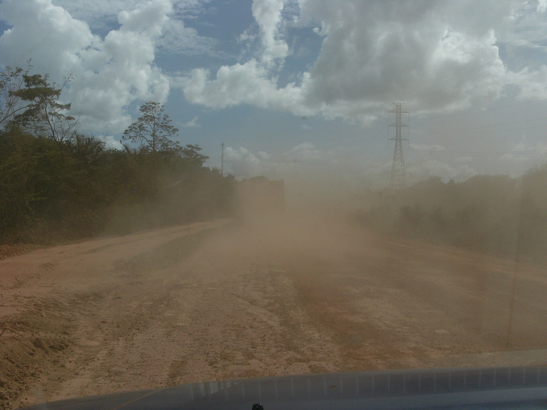

Official travel guidance describes interior dirt roads, sparse services and bridges that can deteriorate quickly in the rainy season. A normal city rental may be excluded from those roads by contract or insurance. Ask the lodge, guide and operator the same questions: current surface, last fuel, safe daylight window, communications, vehicle clearance, recovery method and whether a driver or boat transfer is safer.
Rain, drainage, fuel and communications
The Meteorological Service’s public guidance describes two rainy periods and two dry periods, but also records intense local rainfall and flooding. Greater Paramaribo uses canals, pumps, sluices and rivers to discharge rainwater, and the national infrastructure plan notes that parts of the drainage system are poorly maintained. The practical rule is simple: if water covers the road or hides the edge, do not enter it.
Check the district forecast, the hotel approach and the next bridge before setting out. Leave time for a shower to change the surface. Keep the tank above the amount needed for the next confirmed station and a turn-back. The March 2026 fuel notice gives a price policy snapshot, not a guarantee of supply, opening hours or card acceptance at a remote pump.
For communications, buy a local plan or test roaming in Paramaribo, save offline maps and write down the rental and accommodation contacts. Telesur’s prepaid information and mobile FAQ describe local data services and network bands. Digicel’s store locator shows service points in Paramaribo, Albina and Nickerie. Coverage can still disappear between settlements, so tell someone the route and the planned arrival time.
Border permissions and emergency response
The rental contract controls whether its vehicle may cross a border. Enterprise states unrestricted driving in Suriname only. Finalrentals prohibits cross-border travel. A border authority may accept a vehicle with the right registration and insurance while the rental company still refuses permission. Keep the vehicle domestic unless the operator has written approval naming the country, dates, route, insurance and return plan.
Save the official Police Force contact numbers and the government’s Justice and Police contact page before departure. The published emergency lines are 115 for police, 110 for fire and 113 for urgent emergency care. When calling, give the nearest road name, direction, bridge, village or landmark, the vehicle plate, injuries and hazards. Move away from traffic only when doing so is safer than staying with the vehicle.
After a crash, follow the local instruction about the vehicle, call the rental company and preserve the police reference, photographs and contract records. After a breakdown, use hazards, leave the live lane if possible and wait for the named recovery service. Do not accept an informal repair or cross a flooded section without written instructions from the operator and a safe route back.
Sources and review date
This page was reviewed on August 18, 2026. Legal age and vehicle categories were checked against the Rijwet 1971 and Rijbesluit 1957. Foreign-licence and IDP preparation was checked against the Suriname Police international-permit guidance, Enterprise Paramaribo rental conditions and Finalrentals terms.
Traffic design, parking context, bridges and road status were reviewed through the Public Works cross-section guideline, Avobakaweg repair notice, primary-road maintenance programme, Public Works infrastructure dashboard and the Suriname infrastructure vision. Ferry and border information was checked against the Canawaima management notice, Canawaima service notice and French Guiana border-post notice.
Rain, drainage, fuel and communications were checked against the Meteorological Service notice, fuel-price notice, Telesur prepaid page, Telesur mobile FAQ and Digicel store locator. Safety context and emergency contacts were checked against the U.S. Department of State Suriname travel advisory, Suriname Police contact numbers and Justice and Police contact page. Recheck the rental contract, road notices, bridge or ferry status, weather, fuel and emergency lines for the actual travel date.
Related driving resources
- International Driving Permit guide
- Car rental insurance guide
- Cross-border driving checklist
- Emergency numbers tool
- Trip planner
Related destinations
Frequently Asked Questions
- Which side of the road does Suriname use?
- Suriname drives on the left. Set the habit before leaving the rental counter: keep left, check the mirror before moving across a lane, and expect pedestrians, bicycles and motorcycles to share narrow edges. A familiar navigation app does not change the local traffic side.
- Can I drive in Suriname with my foreign licence?
- Carry a valid licence issued in your country of residence, your passport and the rental agreement. Suriname's public guidance for newcomers says a driver needs a licence and, depending on the length of stay, may also need a local driving permission. Ask the Police Force licence division and the named rental branch to confirm the exact document for your nationality and stay.
- Do I need an International Driving Permit in Suriname?
- Treat an IDP as part of the rental document pack unless the named operator confirms a readable Latin-script licence is sufficient. The current Enterprise Paramaribo terms recommend an IDP for licences that are not in English or Latin characters and require an IDP or notarised English translation for non-Latin licences. A national licence remains necessary; an IDP does not replace it.
- What is the legal minimum driving age in Suriname?
- The Rijwet 1971 sets 18 as the minimum age for a licence to drive motor vehicles other than two-wheeled vehicles. That is a legal licence boundary, not a promise that a visitor aged 18 can rent a car. The rental contract, vehicle class, licence history, payment card and insurance terms can set a higher threshold.
- How old must I be to rent a car in Suriname?
- There is no single rental age for every operator. Enterprise's Paramaribo page currently states 21 to 75, with a young-driver fee from 21 to 24. Finalrentals publishes 19 to 70 with a surcharge for younger drivers, while local companies can use another threshold. Get the age, licence-tenure, deposit and vehicle-class conditions in writing before paying.
- Which documents should I show at a Suriname rental desk?
- Prepare the original driving licence, IDP or approved translation where relevant, passport, reservation, payment card and a record of the named drivers. Ask for the vehicle registration, insurance evidence, roadside number, fuel policy, damage record and permitted route. Photograph the plate, odometer, wheels, glass and existing damage before leaving.
- What speed limits should I use in Suriname?
- Use the sign, road class, police direction and work-zone control in front of you. Public Works planning documents describe different design speeds for different road types, but that guidance is not a safe substitute for a posted legal limit on a specific road. The page therefore does not invent a national urban, rural or highway number. Slow down for rain, pedestrians, potholes, bridges and poor visibility.
- How should I park in Paramaribo?
- Choose a confirmed hotel lot, supervised car park or legal marked space before entering the busiest blocks. Do not stop on a bridge approach, in front of a drain or driveway, at a junction, or where a temporary police closure applies. Check the sign at the actual space and keep the receipt or payment record if a fee is charged.
- Are there one-way streets in Paramaribo?
- Yes, one-way arrangements and temporary circulation changes exist, especially around central streets, works and events. Public Works design guidance distinguishes one-way destination roads, while police notices can close a street or direct traffic through a different sequence. Read the arrow at the entry, follow police instructions and do not reverse against traffic when a turn is missed.
- Is a car useful inside Paramaribo?
- It can be useful for a planned arrival, airport transfer or a route outside the centre, but a car is not automatically the easiest way to visit the central streets. Secure parking first, keep luggage out of sight and leave a margin for congestion, pedestrians, open drains and water on the road. A short walking connection from a confirmed car park can remove several low-value turns.
- What is the East-West Link in Suriname?
- The northern East-West Link connects the coastal road system between the Nieuw Nickerie area in the west and Albina in the east, passing through the Paramaribo region. Treat it as a long corridor with settlements, bridges, roadworks, fuel decisions and changing surface quality, not as one uniform motorway. The government's infrastructure plan also describes future widening and cross-border connections, which should not be mistaken for work already complete.
- Which bridges matter on a Suriname road trip?
- The Jules Wijdenbosch Bridge crosses the Suriname River on the East-West Link, while the Coppename Bridge and other river crossings shape westbound timing. Public Works maintains an infrastructure dashboard for bridges, piers, dams and traffic installations. Check current notices and obey weight, lane, repair or police restrictions at the crossing rather than relying on an old route description.
- Can I take a car ferry from Suriname to Guyana?
- The Canawaima service links South Drain in Nickerie with Moleson Creek in Guyana. A ferry route is a border operation, not a normal continuation of the highway: confirm sailing status, passport and customs requirements, insurance, vehicle documents and written rental permission. The management company has described operational challenges, so keep a fallback day and do not build a flight or lodge connection around an unverified departure.
- How do I cross between Albina and French Guiana?
- The Suriname and French Guiana sides meet across the Maroni River, with the official border posts at Albina and Saint-Laurent-du-Maroni. This is a river crossing with separate immigration and vehicle rules, not a road bridge. Confirm opening hours, entry documents, insurance territory and the actual boat arrangement with the border authorities before taking a rental car to the waterfront.
- What is Avobakaweg, and why is it also called Afobakaweg?
- Avobakaweg is the road toward the Para and Brokopondo area and is still often called Afobakaweg in older maps, booking notes and public records. Keep both names in your route search. The Roads Authority has published recent repair notices for subsidence and damaged culverts, so a route shown as open can still require a bypass, lower speed and a daytime crossing.
- Are roads in the Suriname interior paved?
- Do not assume that a road into the interior is paved or suitable for an ordinary rental car. Government documents distinguish the main coastal network from southern and interior connections, and official travel guidance describes dirt roads, sparse services and bridges whose condition can worsen in the rainy season. Ask the operator or local lodge for current access, vehicle type, recovery and permission before departure.
- When are Suriname's rainy seasons?
- Suriname has two rainy periods and two shorter dry periods, with timing that varies across the country. The Meteorological Service describes a long rainy period around May to August and a shorter rainy period around December to January, while government climate documents warn that the pattern is variable. Use the current forecast for the exact district instead of treating a seasonal label as a road guarantee.
- How should I plan around flooding and drainage?
- Greater Paramaribo relies on canals, pumps, sluices, sewers and rivers to move rainwater, and government infrastructure documents note maintenance gaps in parts of the system. After intense rain, avoid roads covered by water, low-lying approaches and shoulders whose edge is hidden. Ask the hotel or local operator which road is passable, and turn around before the water removes your view of the surface.
- Where should I refuel before leaving Paramaribo?
- Fill the tank before a long eastbound, westbound or interior stage and confirm the next reliable station with the rental branch or local operator. A government fuel-price notice does not promise that a station is open, stocked or able to accept your card at the time you arrive. Keep enough fuel for a delay, a bridge queue and a turn-back option.
- Can I rely on phone service outside Paramaribo?
- Buy or confirm a local SIM or roaming plan before leaving the city, then download maps and save the rental and lodge contacts offline. Telesur publishes mobile data information and frequency details, and Digicel lists branches in Paramaribo, Albina and Nickerie, but a shop location is not proof of continuous coverage along an interior road. Tell someone your route and expected check-in when service may disappear.
- Can a Suriname rental car cross into Guyana or French Guiana?
- Never infer border permission from the fact that a public ferry or boat exists. Enterprise states unrestricted driving in Suriname only, and another published Suriname rental contract prohibits cross-border travel. Ask the operator for written approval, vehicle documents, insurance territory, customs paperwork, recovery support and any border fee. If the contract is silent, keep the vehicle inside Suriname.
- What should I prepare for a cross-border vehicle trip?
- Prepare the original licence and passport, vehicle registration, rental authorisation, insurance or cover note, entry documents and any required international permit or translation. Confirm the border post, ferry schedule, opening hours, permitted country, return route and whether the vehicle may board. A driver's legal ability to cross is separate from the rental company's permission to take its vehicle abroad.
- What number should I call the police in Suriname?
- Call 115 for the police emergency line. The Police Force publishes 115 as its alarm number, while the government's Justice and Police contact page lists the same line alongside other services. Give the road, direction, nearest bridge or settlement, vehicle plate, injuries and immediate hazards. Call the rental roadside number separately once the scene is safe.
- What are the fire and urgent-care numbers?
- The government's contact information lists 110 for the fire service and 113 for urgent emergency medical care, with hospital contact numbers also provided. Save 115, 110 and 113 before a remote drive, and keep the rental contract's roadside number in the same note. Numbers and local response arrangements can change, so recheck the official contact page before departure.
- What should I do after a crash or breakdown?
- Protect people first, switch on hazard lights and move out of live traffic only when it is safe. Call 115 for danger or injury, 110 for fire and 113 for urgent medical help, then notify the rental company and follow its accident and recovery instructions. Record the location, photographs, police reference, fuel level and damage, and do not drive through floodwater to reach assistance.
Information Sources & Disclaimer
This guide compiles information from the official transport authorities, road operators, government travel information, and automobile associations linked for Suriname.
While we strive to keep this information as accurate and up-to-date as possible (last reviewed: August 2026), traffic laws and toll rates can change without notice. We recommend verifying critical information with the local authorities or your car rental agency upon arrival.
Learn more about our Editorial Process →Compare Your Origin and Destination
Use the comparison tool to check driving side, units, documents, and other destination data for your route.